A Non-Profit Foundation Dedicated
to Preserving Our Maritime Heritage
Founded by Clive Cussler
A Non-Profit Foundation Dedicated
to Preserving Our Maritime Heritage
Founded by Clive Cussler
Battle of Memphis
Expedition to find the SULTANA and the Confederate gunboats sunk during the battle of Memphis. April 1982.
The burning of the fine sidepaddle steamer, SULTANA, in 1865 immediately after the end of the Civil War was the worst ship disaster in number of lives lost in North America. Over 1240 people were known lost. Twenty-two more than the Titanic.
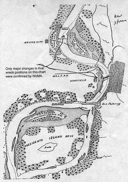
Again, Walt Schob and I, along with the Schonstedt gradiometer, gathered in Memphis, Tennessee, in preparation to look for the shipwrecks. Using an 1871 Mississippi River pilot’s map showing the marked positions of the wrecks, it took no great power of deduction or strain of gray matter to find and pinpoint the wrecks with the gradiometer. The chart was right on the money at nearly every site.
 |
| Figure 1. (click to enlarge) |
After contacting Jerry Potter, a Memphis attorney who had been working with the farmer who had dug up some artifacts from the wreck, we set out to make a firm position of the remains. We searched the area where the artifacts were found. More were detected and excavated.
What concerned me, however, was my failure to record a large reading indicating boilers. And, according to the pilot’s chart, we were working almost four hundred yards too far south of the marked wreck site.
We came to the conclusion that due to the flood tide during the tragedy, the hulk of the steamer was hung up in trees along the old river bank during the salvage. The salvors were forced to remove the loose wreckage onto rafts, then towing the debris the four hundred yards down river where it was unloaded on shore.(see Figure 1)
Foul weather was closing in, making it nearly impossible to tramp through the mud of a soybean field. I laid out a grid for Potter, indicating my preference for the Sultana’s grave. Then Walt and I headed back to Memphis to prepare for the next two
days of searching the river for the Confederate gunboats.
 |
| Figure 2. (click to enlarge) |
Potter later searched my preference area and, after being thrown off by a steel well casing, homed in on the boilers. I suggested a drilling core operation, which was set into operation. The core brought up charred wood over a wide area marking the Sultana’s burial site nearly two miles from the present course of the Mississippi, twenty feet deep under a farmer’s soybean field in Arkansas. (see Figure 2)
As of this writing, Potter is having a difficult time trying to set an excavation project into motion. The same old story. I offered to help in the funding, but so far no takers.
Walt hired a hippie who lived in a dingy houseboat and sold scrimshaw. He borrowed a friend’s inboard speedboat and off we went under a dreary gray sky that sprinkled occasionally but never soaked us.
Our recorded readings conform almost exactly to the old pilot’s river chart. The only difference is that the river channel has moved about three hundred yards to the west toward Hopewell Bend across from the city of Memphis.
STEAMER SAINT PATRICK
She lies 320 yards due east of the west bank and barely a hundred yards north of the highway 40 bridge.
GENERAL LOVELL
River has moved west and the gunboat sits almost in the middle of the main channel 620 yards northwest of the tip of Joe Curtis Point and almost due west of the library.
GENERAL BEAUREGARD
This gunboat rests just around the Hopewell Bend not twenty-five yards south of the shore. During one extremely low river, her timbers could be seen.
GENERAL THOMPSON
About three quarters of a mile west of the Beauregard only a few yards from shore. There are no landmarks in this area. Just a worn embankment rutted with kids driving three-wheeled off road motorcycles. The shoreline runs almost exactly as it did in 1862.
PLATTE VALLEY
This steamer, which ran afoul of the Thompson and sank next to her, lies only twenty yards southwest of the gunboat.
All Rights Reserved © | National Underwater and Marine Agency
All Rights Reserved © | National Underwater and Marine Agency
Web Design by Floyd Dog Design
Web Design by Floyd Dog Design